


In today’s first Patreon-fueled shout-out:
If you're curious and want to dig deeper, there's another podcast you might want to try. Especially if you ask why, and not just what. And if you belive that politics should be about making communities better.
If so, check out Bold Dominion, a biweekly podcast from WTJU 91.1 FM. Bold Dominion is a state politics explainer for a changing Virginia. Their latest episode asks: Where does Virginia’s trash come from and who does it get dumped on? Check it out at BoldDominion.org.
In today’s newsletter:
The Charlottesville Planning Commission learns more about a proposal from nonprofit housing groups on an affordable housing overlay in the Future Land Use Map
The seven-member appointed body also recommended a request from Charlottesville’s public housing authority to drop a condition of a critical slopes waiver
And there are now two fatalities from a house fire in Fifeville early Wednesday morning
A second person has died after a fire in a home in Fifeville early Wednesday morning. Crews were called to the 1000 block of Cherry Avenue to a structure fire. According to a release, firefighters rescued one person who was trapped. That person and two others who escaped were taken to the University of Virginia Medical Center, and one died soon after arrival. This afternoon the Fire Department reports a second person has since died and the third occupant is still hospitalized. The Fire Marshal’s office is investigating.
Time to catch up with activities this month from the Charlottesville Planning Commission, who met on July 13. I previously reported two other items from the meeting in the July 16 installment of this newsletter. Now it’s time for the rest. (download the agenda packet for details)
Commissioners got details on an alternative version of the Future Land Use Map that is part of the Cville Plans Together initiative. If you’re unfamiliar, check out previous coverage:
Charlottesville Planning Commission gets first look at draft Future Land Use Map (April 13)
May: A busy month for Charlottesville to plan together (May 9)
Charlottesville Planning Commission briefed on public comment for Cville Plans Together initiative (July 12)
The idea for an overlay district for affordable housing stems from members of the Housing Advisory Committee, one of whom is the executive director of the Piedmont Housing Alliance.
“The proposal we are going to discuss tonight reflects our effort to distill the common ground from the spectrum of insights, concerns and hopes that we have heard,” said Sunshine Mathon. “Consistently across all of the discussions we’ve heard the following. We’ve heard common praise for protecting and preserving historically Black and low-income neighborhoods. We’ve heard common support for addressing affordability broadly across the city and that mostly everyone is okay with future affordable housing in their neighborhoods. And lastly we’ve heard concern that density for density’s sake alone doesn’t serve anyone well.”
The proposal suggests creation of a new low-intensity residential category that would limit density in historically Black and low-income neighborhoods like Fifeville, 10th and Page, and Rose Hill.
“This land use would be the base land use for historically Black and low-income neighborhoods to reduce development pressures by essentially keeping in place the existing density allowances in these neighborhoods,” Mathon said.
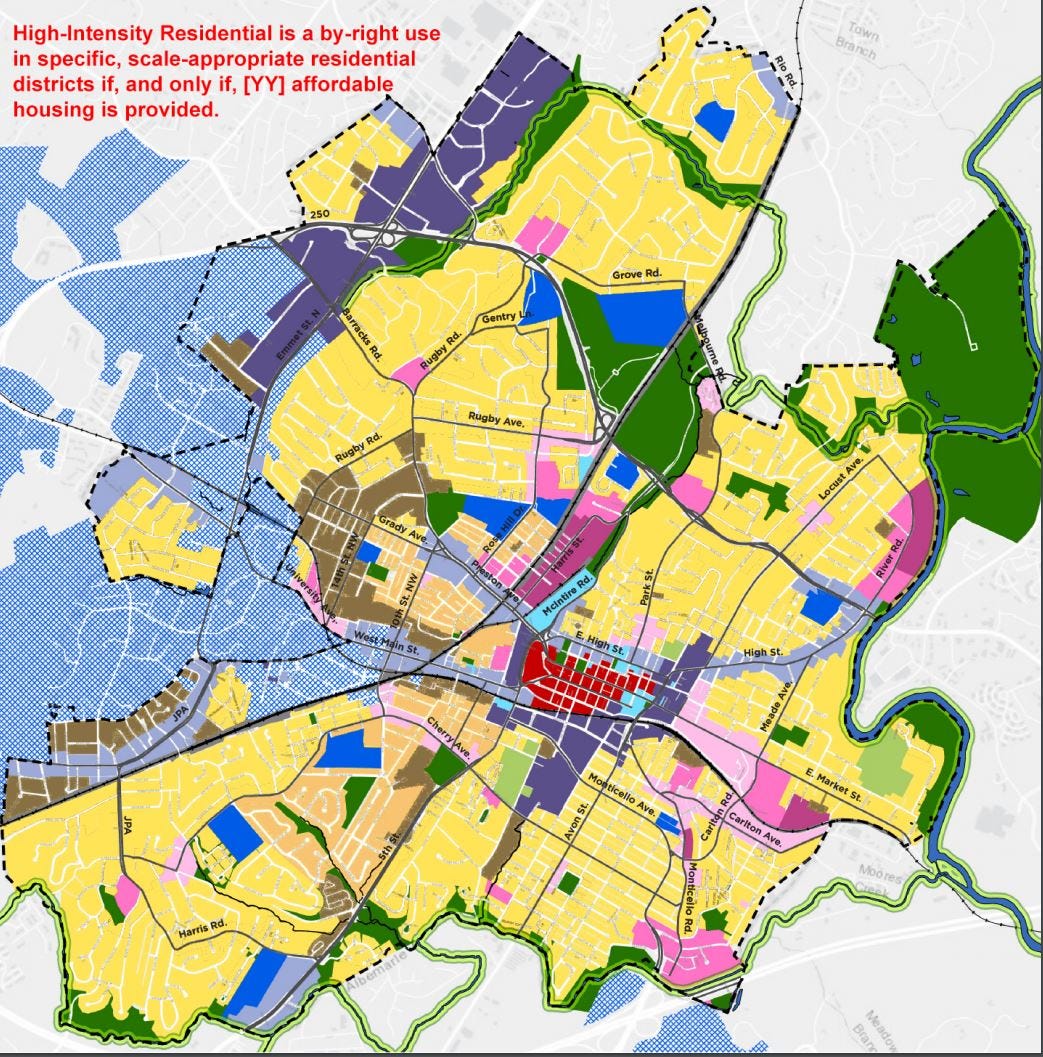
A second concept is that the rest of the city would have the General Residential land use category which as described by the consultant would allow three units per lot.
“Recognizing that growth has been historically accommodated on the backs of low-income neighborhoods, this would shift growth patterns to higher income areas,” Mathon said. “To some extent.”
The third concept would be to only allow higher-intensity residential to developments that kept a portion of the units below-market.
“This proposal recommends that medium-intensity residential be a by-right use in all parts of the city if and only if affordable housing is part of a proposed development,” Mathon said. “This recommendation privileges affordable housing and guides density with purpose in all neighborhoods.”
Mathon said acceptable practical constraints include topography, lot sizes, and infrastructure. He said the revised maps that have been developed are not final and also need to be refined.
“Our proposal is intended to establish common principles that set the stage for the next level of detailing,” Mathon said.
Mathon also said the proposal does not currently define affordability but he set out what needs to be known.
The minimum percentage of affordable units in a particular development
The depth of affordability of units
The length of time those units must stay affordable
Dan Rosensweig, the executive director of Habitat for Humanity of Greater Charlottesville, said there are areas of the city where it should be easier for developers to build a lot of units.
“There may be areas of the city for example that don’t want to be general residential, but they are really the areas of the city, and I’m not going to name specific places but we know, a lot of people know where they are,you really don’t want to put the extra restrictions on them, where you just want density, intensity, and volume to happen,” Rosensweig said.
Commissioner Rory Stolzenberg said he supported the suggested framework because it builds upon language from other documents such as the recently adopted affordable housing plan.
“In the affordable housing plan it says explicitly under the multifamily by-right zoning ‘establish a mandatory inclusionary zoning as part of any revision to the multifamily zoning,’” Stolzenberg said. “To me I think it does make a lot of sense to add that directly into our descriptions in the map.”
Stolzenberg also supported the idea of more density throughout the city if below-market housing is required. A reminder that medium-scale would allow between eight to 12 units per lot.
“I also think it makes a lot of sense to allow that possibility of medium-scale apartments everywhere with that requirement for affordability,” Stolzenberg said. “And that saves us a lot of kind of fine-grained picking out of things in the map versus letting that go to the site plan level requirements in making sure that for lots where that is proposed the infrastructure is actually in place and the physical constraints and that is doable.”
Stolzenberg said this way decisions about infrastructure would be made at site plan level. He did suggest a name change from “low-intensity” to “sensitive neighborhood.”
Rosensweig said the goal was to create more affordable housing.
“You can’t do a mapping exercise without thinking about the history of the map and the intentionality of the zoning map to calcify what had been put in place with restrictive covenants,” Rosensweig said. “To me, what is really important as somebody who is a champion of affordable housing and who has also tried to develop affordable housing is that it should be available, opportunities for affordable housing should be available throughout the city. A family’s zipcode shouldn’t be their destiny. I think one of the primary purposes of this map is to create the conditions by which affordable housing can happen in every neighborhood.”
Commissioner Jody Lahendro said he liked the idea, but still has concerns about the map provided by Rhodeside & Harwell. He posed several questions as the concept continues to be shaped.
“Who establishes whether a development is compatible within the context?” Lahendro asked. “What are the benchmarks? What are the requirements? Is it done on a project by project based on the context directly around that project? Or is it done by a zoning district, or a district of some kind?”
Commissioner Chair Hosea Mitchell offered these comments to the consultant.
“Density for the sake of density is dumb,” Mitchell said. “Density with a purpose, density that is smart, density to borrow from Sunshine, density that privileges affordability is good and the overlay as it has been presented does just that, it provides density with a purpose, the purpose being affordability.”
City Councilors were also on the call. Commissioner Michael Payne said he supported the framework.
“It’s a good framework for addressing some of the concerns a lot of people have over ensuring that density is actually promoting affordability to the maximum possible extent,” Payne said.
However, Councilor Payne had concerns the regulations aren’t too restrictive that developments can’t work out financially.
“I just want to make sure we don’t end up in a situation where projects don’t pencil out and we have a de facto downzoning for some neighborhoods that have racial covenants and redlining,” Payne said. “And then likewise, how do we ensure that we’re actually monitoring and keeping units affordable as part of the requirements of any overlay.”
Commissioner Stolzenberg said many of the details about affordability can be answered while the next phase gets underway. But he said the proposed overlay will help guide that conversation.
“Clearly the real details of levels and all that needs to be pushed to the zoning ordinance rewrite where we’ll have the map done,” Stolzenberg said. “But it is also important now to basically for your small projects that are just getting into this overlay, in determining what your base level is, you’re going to be setting those levels implicitly, right? So if general residential allows triplexes, if you’re building a fourplex, you’re saying that it has to be 25 percent affordable, which might preclude fourplexes all together. So I think that while the bulk of the details should be pushed out later, there is some amount that you should need to be thinking about now.”
The consultants with Rhodeside & Harwell continue to go through the feedback from the official community input process, which ended on June 13. The next official meeting with the Planning Commission is tentatively scheduled for August 31. Jennifer Koch is the project manager for the Cville Plans Together initiative and she said they will take the proposal into consideration as it fits in with the overall strategy.
“We have met with at least Dan and Sunshine a couple of times just to make sure we understood what was being proposed,” Koch said. “Like Sunshine said, some of these thoughts about an overlay we have in the chapter of Comprehensive Plan as part of the next step was zoning.”
Mitchell said he wanted to complete the Planning Commission’s role in the Future Land Use Map this by October so the currently elected Council could take a vote. Two Council seats are up this November.
*
But we’re not done with the Cville Plans Together initiative just yet today! This past Monday, Council held the first of two readings on approval of additional $165,000 to expand the scope of the project. Specifically, they’re to be directed to study how the Charlottesville Affordable Housing Fund is used, as well as a further study of inclusionary zoning. Some of the funding would come from the Charlottesville Affordable Housing Fund, which was created in 2007 as a dedicated account for housing projects. Alex Ikefuna is the director of the Department Neighborhood Development Services.
“This request is essentially a fund transfer to enable staff to complete a couple of related projects designed to implement the affordable housing plan that was endorsed by the City Council a couple of months ago,” Ikefuna said.
The work will include a review of the performance of the past ten years of the Charlottesville Affordable Housing Fund.
“The program is designed to evaluate whether the city’s investment is actually producing the desired outcome,” Ikefuna said.
Ikefuna said the additional funding for the inclusionary zoning study is not related to the affordable housing overlay presented by Habitat for Humanity and the Piedmont Housing Alliance. He did offer this caveat to Council about expectations for this process.
“Everything that comes out of the Future Land Use Map and perhaps the zoning ordinance and maybe portions of the overlay that would be integrated into the Future Land Use Map has to be what the market can respond to,” Ikefuna said. “We have to be cognizant of that.”
Councilor Heather Hill has been a member of the Housing Advisory Committee and is glad to see the review of the Charlottesville Affordable Housing Fund will be conducted.
“I just think this is really long overdue,” Hill said. “I know the Mayor and I have discussed throughout our time on Council and just making sure we have a process in place that does have that accountability but also just looking back historically and understand what has and hasn’t been working so that we can have the most effective use of city dollars moving forward.”
I’m in the midst of conducting my own review of the Charlottesville Affordable Housing Fund, and if you’re a paying Substack subscriber, you’ll get that report as soon as I’m done with it. After that it will be posted to the Information Charlottesville website. About a quarter of you are paying, and I’m grateful for your support to help me keep an eye on things for all of us.
You’re reading Charlottesville Community Engagement. In today’s second Patreon-fueled shout-out: Help support Black-owned business in the Charlottesville area. Check out the Charlottesville Black Business Directory at cvilleblackbiz.com and choose between a variety of goods and services, ranging from beauty supplies, professional services, and e-commerce. Visit cvilleblackbiz.com as soon as you can to get started.
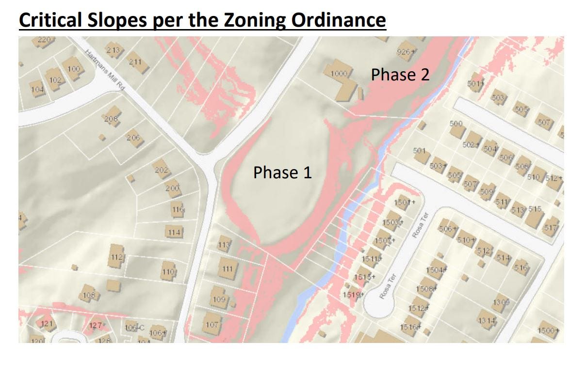
Earlier in the Charlottesville Planning Commission meeting, Commissioners voted unanimously on a proposal from the Charlottesville Redevelopment and Housing Authority to alter one of the conditions in a critical slopes waiver they were granted in early 2019 for the first phase of the redevelopment of South First Street. Carrie Rainey is a planner with the city of Charlottesville.
“The previously granted critical slopes waiver allows for construction and land disturbing activities within critical slopes for a development that would include 62 multifamily residential units in three buildings and a community resources center,” Rainey said.
City code defines a critical slope as one that has a grade of 25 percent or higher, and also contains either a horizontal run greater than 20 feet or is within two hundred feet of a waterway. The idea is to prevent erosion and prevent sediment from entering waterways, which kills macroinvertebrate life. The waterway Pollocks Branch is within the latter.
After construction at South First Street began, CRHA notified the city it would not be able to comply with a condition of the slopes waiver that required a phased construction so that two buildings on First Street would be built first “in order to create a better stabilized site during construction and to facilitate more effective erosion and sediment control measures.”
“The purpose of that is building three is placed on the trap that serves to treat the sediment from the areas where [buildings] two and three are being built,” said city engineer Jack Dawson.
CRHA officials maintain that because of supply issues, they need to construct all three buildings at once in order to lock in costs. On the day of the Commission’s discussion, CRHA’s engineers suggested that a combination of enhanced silt fences and placement of mulch to slow the flow of stormwater runoff that would go to Pollocks Branch, which flows into Moores Creek, which flows into the Rivanna River.
“That’s mostly not acceptable for this type of application and there are sort of some further concerns I have with that as well,” Dawson said.
After spending a few minutes detailing what he felt was problematic about the plan, Dawson reached a conclusion, though he said he understood the importance of this project.
“It’s going to be difficult to ensure that what’s done here is actually enforceable and carried out,” Dawson said. “There’s been significant problems on the site so far with conforming with the erosion and sediment control scheme.”
City Attorney Lisa Robertson said the critical slopes waiver process happens at the legislative level, sometimes long before a site plan will be submitted.
“So the situation you wind up with is that you vote on these things and you adopt conditions such as let’s sequence the buildings to make sure we provide extra protections for the critical slopes areas and minimize disturbance and then you find out when you get closer to construction through the process of doing the erosion and sediment control plan that certain things can or can’t be done with that,” Robertson said.
Robertson said if the Commission granted the waiver, CRHA and city staff would still have to work to ensure the plan complies with Virginia’s erosion and sediment control regulations.
“What you really need to decide tonight is whether or not you’re going to get rid of the construction sequencing condition and whether or not you need to get rid of any other conditions,” Robertson said.
Robertson suggested this is one area to review as the zoning code is updated.
Ashley Davies of Riverbend Development led the CRHA’s presentation. The request is centered on a need to build all three buildings are materials are found due to supply chain issues related to the availability of lumber during the pandemic.
“We certainly don’t have any ill intent and we are just as committed to protecting Pollocks Branch as anyone else,” Davies said.
Davies said the disturbance of slopes has all occurred and stabilization methods are in place, but the condition on phasing does not work in order to meet the project schedule.
“We’ve also think I spent a lot of time working with staff to try and make adaptations on site as we’ve discovered issues but basically what we found is that staff is like, ‘well, we can’t make any of these recent adaptations because this was a Planning Commission and City Council condition’ so it doesn’t really allow the [erosion and sediment process] to adapt or be amended with staff,” Davies said.
Davies said she did not feel Pollocks Branch would be in any danger of environmental harm. Scott Collins, a civil engineer working on the project, said the sediment trap would still be in place during construction.
“We are still achieving 100 percent stabilization on the site from the parking lot up,” Collins said. “For everything that would go to that sediment trap, before we remove that sediment trap we are stabilizing that per Virginia stormwater and erosion and sediment control standards.”
Dawson said in a recent site visit, he saw sediment being discharged into Pollocks Branch and that construction was outside of the limits of disturbance outlined in the plan. Dawson also said he chose not to take immediate action.
“We certainly could have issued a stop work order immediately,” Dawson said. “That’s not what we did.
The Commission voted unanimously to recommend dropping the waiver. It will next move on to City Council.
Thanks for reading! Please send it on to someone else, or leave a comment.


Share this post