


On March 30, 2021, the Charlottesville Planning Commission once again took up discussion of a map which is intended to signal to property owners and the public what uses are desired for specific properties across the city’s 10.3 square miles.
The firm Rhodeside & Harwell unveiled a draft of what is known as the Future Land Use Map in the same month that Charlottesville City Council endorsed an affordable housing strategy they put together that is intended in part to find more locations to build new units to increase the overall housing stock.
“This is where the conversation will get more difficult,” said Jennifer Koch of Rhodeside & Harwell. “We know this is a first draft and there’s going to be refinements and revisions as we move forward.”
Commissioners clashed in 2018 over a previous version of the map. Some commissioners insisted on designating more land for intense residential use. Others wanted a more gradual approach.
The March 30, 2021 presentation was led by Ron Sessoms, a Rhodeside & Harwell veteran who previously worked on the West Main Streetscape project. One change from the 2018 draft future land use map is that colors correspond to specific parcels, rather than a gradient that had been used.
“The parcel-based approach is very similar to what was developed in 2013 when you had crisp lines between different land uses based on parcels,” Sessoms said. “The land use gradient approach would be more of a fuzzy boundary. There’s not hard edges. It wouldn’t be defined by parcels themselves, but it allows flexibility in the future because the lines are not as crisp as a parcel-based map.”
Sessoms said RHI is recommending a parcel-based approach because that will more clearly inform the rewriting of the zoning code, which is the next step in the Cville Plans Together initiative. He also said a gradient-approach would involve less certainty for developers. Individual land use decisions in Virginia most always take the Comprehensive Plan into account, but its guidance is not legally binding.
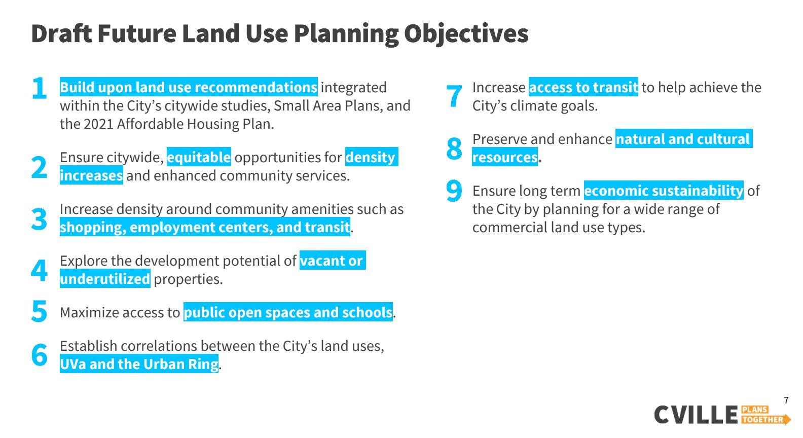
Sessoms said changes in this map have been with nine principles in mind. The first is to build upon recent studies and the recently endorsed affordable housing plan.
“We’re providing more housing opportunities including affordable housing and we’re including those areas where people want to live,” Sessoms said. “This would be places near parks, schools, transit, city services, and employment centers.”
Sessoms said an emphasis is placed on the need to provide a variety of different housing types. One of the equity considerations that is being taken into account is to increase “the availability of housing in single-family neighborhoods that have historically had exclusionary zoning, while minimizing community disruption and displacement pressures in low-income neighborhoods.”
“We’ve heard a lot about how we can begin to provide equitable housing distribution throughout the city and doing that through introducing a variety of housing types in different areas of the city who historically have not included that type of approach,” Sessoms said.
However, Sessoms cautioned against seeing the future land use map as the only way to accomplish these goals. And already locations of various nodes have been shifted around the draft map from February to March. They will further shift as the map is discussed by more people.
“This is the first draft of the land use map,” Koch said “We know there are going to things that need to be adjusted.”

The most intense use shown on the map is dark purple for downtown core. Sessoms said that building heights in this area could be as high as 10 stories to match the Landmark skeleton. He said that future development should include residential uses to offer people the chance to live there.
Commissioner Jody Lahendro noted that the downtown core is also covered by the downtown historic and architectural district. He said the Landmark is anomaly in the historic district.
“What is there in here that references the historic districts and their coordinated overlays for your intense urban mix and residential and commercial uses?” Lahendro asked. “There are opportunities provided by those historic districts that if they are delisted due to inappropriate development, it takes away economic opportunities for landowners in those districts.”
Sessoms said the map takes a high level approach to the city’s land uses, but would incorporate existing districts.
“With the building heights, we do say range up to 10,” Sessoms said. “We note there is always a ten story building in downtown and we will have to have architectural control over for these new developments that will control the character and scale of these buildings.”

But the city is more than downtown. The second most intense node in the draft map is “urban-mixed use” which is being used in the Strategic Investment Area (SIA) as well as the U.S. 29 / Emmet corridor.
Commissioner Rory Stolzenberg said he thought one of these two areas might have been painted too broadly.
“I feel like this is a little bit too aggressive in places to go with the entire SIA for example,” Stolzenberg said.
Stolzenberg added that much of the SIA is built out as low-density and that a smaller designation there might be more appropriate.
“I think in the SIA plan, it’s a little bit more nuanced than that,” Stolzenberg said. “It really sees the redevelopment being focused in the big grayfield areas sites like Ix and then stepping down from there.”
Stolzenberg said other areas should receive this urban mixed-designation such as the area around the former Martha Jefferson Hospital which has been redeveloped as a mixed-use site. He also suggested the site of a scrapyard on Carlton Avenue would also be appropriate.
“So put as much density into there as we can in order to help alleviate the pressure on the rest of the city,” Stolzenberg said.
Stolzenberg said he thought the city should designate the Vinegar Hill Shopping Center and the City Yard as a more intense use.
“The Starr Hill Vision Plan that recently passed calls for that to be the most intensely developed part of that area,” Stolzenberg said.
Earlier this month, the City Council added that plan as an appendix to the city’s 2013 Comprehensive Plan. The draft map currently insteads shows the City Yard as “neighborhood mixed use node” which calls for buildings up to four stories.
“Four stories because we don’t want to get too high where it becomes out of context with these finer-grain residential communities that surround many of these areas,” Sessoms said.
Other mixed-use nodes designated on the draft land use map include the Fry’s Spring Beach Club, the intersection of Grove Road and Melbourne Road, and Market Street/Carlton Road east of Meade Avenue. The recommended heights for both neighborhood mixed use corridor and neighborhood mixed use node are four stories.
Commissioner Lyle Solla-Yates said that four stories is not enough in these areas.
“Some of these should be way over four stories,” Solla-Yates said. “Some of them probably under four stories. When we talked about this in 2018, we said five stories as sort of… frankly it’s all arbitrary and it doesn’t make much sense.”
Sessoms said one factor limiting heights in buildings is the need to provide parking to people who live there.
“The higher you go, the more surface parking you get,” Sessoms said. “So if we start going up to five stories, even four, four stories, with that residential or office component, and the commercial on the ground floor, you’re going to need a lot of parking.”
Koch said requirements for parking will come up later in the Comprehensive Plan and zoning re-write.
“The other thing we will be considering these nodes and these corridors is that I think as we’ve said before is how we can provide multimodal access to all of these and along them,” Koch said.
Solla-Yates still wanted the heights to be at least five stories for the neighborhood areas.
“I’m asking why none of them could be five stories,” Solla-Yates said. “What is the public harm?”
Sessoms said there is no public harm, but that there are other considerations to take into account. One of them is thoughts from people who would live nearby.
“We can look at maybe some areas where it may be appropriate to go up to five stories, particularly looking at some of these areas where we have wider parcels that could have more of that potential,” Sessoms said. “We also take into consideration shading and buildings adjacent to residential areas. I remember when we did the future land use framework for West Main Street, there was a lot of concern from the community about looming buildings next to adjacent residential areas. So when we start to suggest these lower heights in the fabric of these communities, we want to be careful how tall we get.”
Planning never really ends and this draft Future Land Use Map incorporates smaller plans that have been adopted, as well as ones underway such as the Urban Rivanna River Corridor plan which is being shepherded by the Thomas Jefferson Planning District. Reviewing the draft map and a little bit of research reveals all kinds of plans for specific neighborhoods.
As stated earlier by Sessoms, the goal of this future land use map is to encourage the production of more housing. Let’s review the definition of “missing middle” housing, which is one of the purposes of the “medium-intensity residential” category.
“These are beginning to encompass many of those missing middle housing types including row houses, townhouses, multi-unit buildings, small house size multi-unit buildings that are compatible with low-intensity neighborhoods,” Sessoms said. “The height of these range up to two and a half stories. That is a residential scale so that they fit.”

Under the draft map, the low-intensity residential category would also include more density through duplexes, triplexes, and accessory dwelling units.
The map will be revised following input from the Planning Commission before a round of community input begins in April.
Commissioner Liz Russell, appointed last September, expressed the concern that higher heights would encourage tear-downs of existing units.
“We need to say that unless a neighborhood has an existing historic district overlay… it’s going to be ripe for tear-downs to build density and not result in affordability,” Russell said.
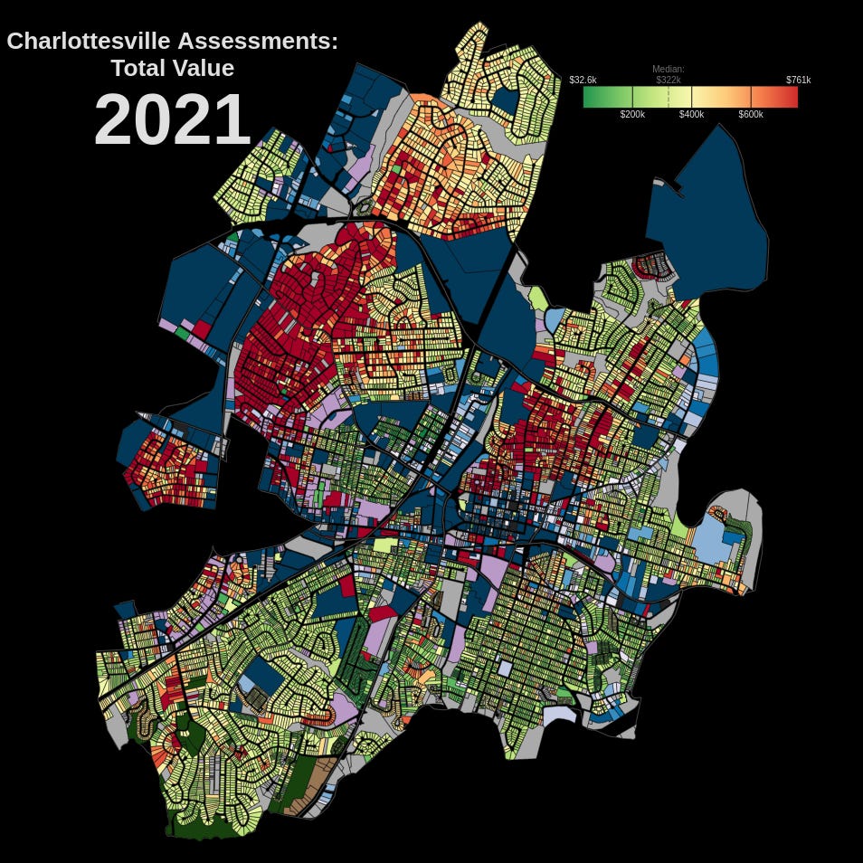
At the meeting, Commissioner Rory Stolzenberg sent around a map which depicted the city by assessed property value. He said many of the wealthiest areas in the city are being depicted as low-intensity residential. He suggested that should change.
“All of those bright red areas in north downtown in particular which is so close to all of the jobs and amenities, and in the Rugby Hills areas and to a little less extent Lewis Mountain, those are all kept as low-density residential in this new map and I think in particular for North Downtown, that really needs to go a lot more of it in a lot higher,” Stolzenberg said.
Commission Chair Hosea Mitchell said many Black households live in neighborhoods that are zoned for single-family residential. He warned of unintended consequences.
“So as you guys begin to think about increasing our density, just remember that you need to also bring equity into the equation and think about how much of the Black community in certain parts of the city are living in R-1 areas, and we to make sure we protect [them],” Mitchell said.
Next steps
Koch and Sessoms said they would take the feedback from Commissioners and will revise the draft land use map once more. The next step will be to begin another round of community input by the end of March.
But the beginning of that process began at the tail end of the March 30 meeting with comments from the public.
Cecilia Mills of the Locust Grove neighborhood said many of the people in her aeighborhood are shocked at being designated as middle-intensity core.
“I know that the consultants are doing their best but there still needs to be better outreach so people know this is coming,” Mills said.
Andrea Massey, a representative of the Charlottesville Low Income Housing Coalition, said the draft map did not go far enough to address what the organization describes as racist zoning practices.
“We need you to go further,” Massey said. “The map right now looking at side by side looks almost exactly the same as it has for decades following the same segregationist lines that were intentionally drawn.”
Thank you for reading. This summary first goes to paid subscribers of Charlottesville Community Engagement and will be posted publicly on April 14.


Share this post