


May: A busy month for Charlottesville to plan together
An introduction to what's happening with Charlottesville's Comprehensive Plan

The month of May will be a busy one for anyone interested in the future of Charlottesville’s built environment. This is also the time when the first public meetings in Charlottesville in over a year will begin to mix in with the virtual ones. The summer should be interesting as differing visions and opinions compete with each other and my hope is to capture the conversation as best I can.
We are now at the point where the process broke down in 2018. One issue was that Planning Commissioners disagreed about the intensity of development as depicted on something known as the Future Land Use Map. The same impasse appears possible again on a Commission that is currently down one member, but this time around there is a different City Council that may be more likely to take a final vote.
What will happen this time around? I do not know, but this article is intended to serve as a review before the first of many events is held this month. I’m here to hopefully answer questions and help steer anyone through the process. Please ask questions and try to understand others views.
There is the potential for much of this process to be misunderstood, but this latest plan seems to follow on in the same vein as the 2001 Comprehensive Plan and the 2007 Comprehensive Plan. If you have questions, please let me know.
What’s happening?
The consultants hired to run the Cville Plans Together initiative have released draft chapters of their version of the Comprehensive Plan, a document required by Virginia code for localities to create and maintain “for the physical development of the territory within its jurisdiction.”
Council last approved an update of the Comprehensive Plan in 2013 after a period in which the Thomas Jefferson Planning District Commission coordinated a joint review with Albemarle County. However, Albemarle County took another year to review the plan more closely with monthly page-by-page reviews by the Board of Supervisors. They adopted their plan in 2015 and their next review is in the planning stages now.
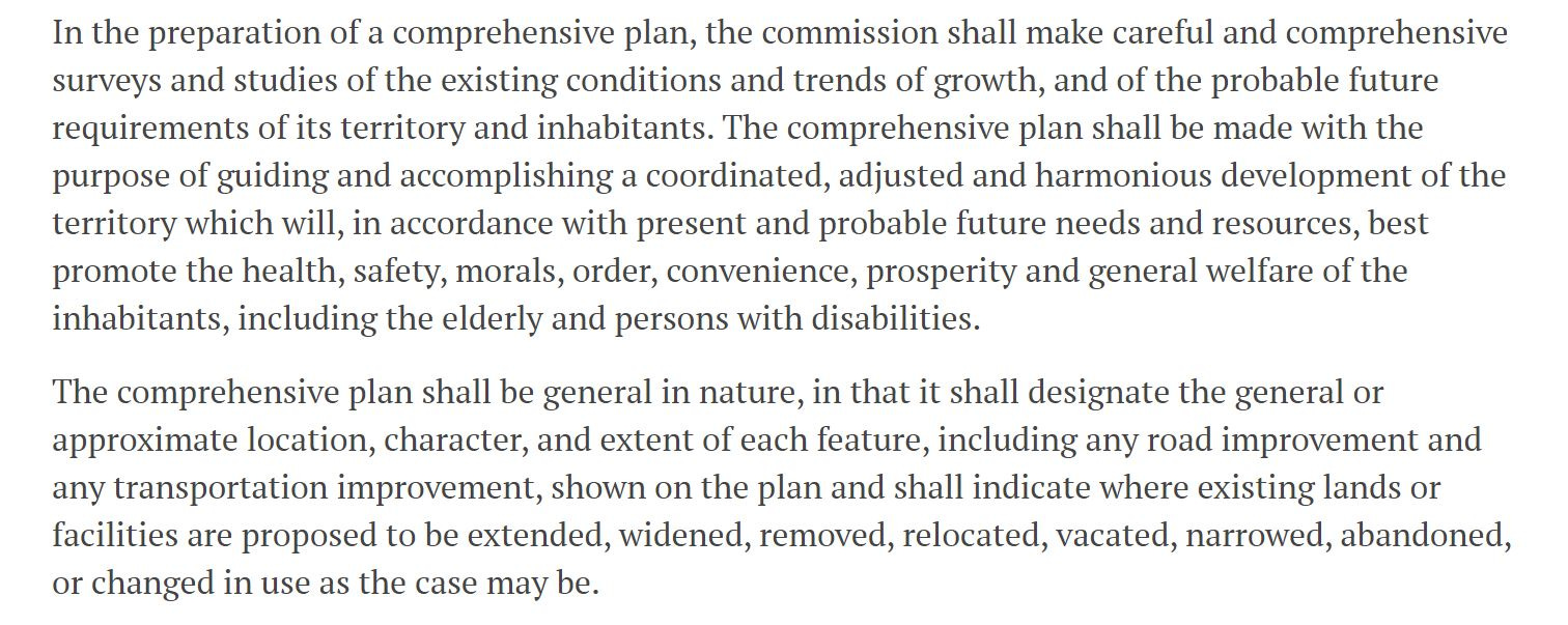
For the next month, it is Charlottesville’s turn to scrutinize the available draft chapters as well as changes to what’s known as the Future Land Use Map. This map will be used to inform the next step in the Cville Plans Together initiative, which is to rewrite the zoning code to reflect the values of the updated Comprehensive Plan and the city’s new affordable housing plan. Council adopted the housing plan in March.
In February of 2019, a previous Council decided to put out the call for a consultant to work on all three plans when the process reached an impasse over disputes over the Future Land Use Map. A request for proposals put racial equity at the heart of the work.
“Housing is at the root of historical structural inequity and oppression in the United States, and it came to be this way deliberately,” reads the sixth paragraph of the request for proposals. “As we build a strategy to achieve a local housing landscape that is healthy, ample, high quality, and affordable, we must be equally deliberate in dismantling the dynamics and the structures that perpetuate continued inequity—structures that often go unnoticed by those of us who benefit from them or don’t directly experience their harm.”
The firm Rhodeside & Harwell was hired to conduct the work. Their process got underway just before the pandemic. That put a damper on community engagement efforts, but the process has continued virtually. City Council adopted an affordable housing plan on March 1. Rhodeside & Harwell released a future land use map soon after.
On March 30, the Planning Commission reviewed the work to date. I recommend reading or listening to my recap of that meeting first before going further. All of the materials for that March 30 meeting are available here.
These products are the result of a lot of long conversations, conversations you can be in. Now it’s your turn. Staff working on the Cville Plans Together initiative wants your feedback through May 31, 2021. (May 2021 Community Review Period)
Future Land Use Map changes since March 30
There have been several amendments to the map since March 30. Several of the land use category names have changed, and the definitions have altered and expanded.
Perhaps the most significant of these is a new name for the yellow category that covers much of Charlottesville. These are single-family neighborhoods and one plank in the affordable housing plan is to open these areas up to additional development through a general up-zoning.
“Single-family zoning, which is prevalent in Charlottesville, has historically been a tool to create and reinforce racial segregation in Charlottesville and nationwide and has restricted the development of housing, contributing to rising housing costs,” reads page 9 of the plan, which was adopted by City Council in March.
The Land Use and Housing chapters of the plan both have several recommendations to change zoning rules to increase housing supply, and many of these recommendations show up as goals and strategies in the written Comprehensive Plan. Both of those documents are advisory, but the zoning map is not. The zoning rewrite will take these directions and translate them into new rules about what can be built where. Staff will take their cue from the Future Land Use Map.
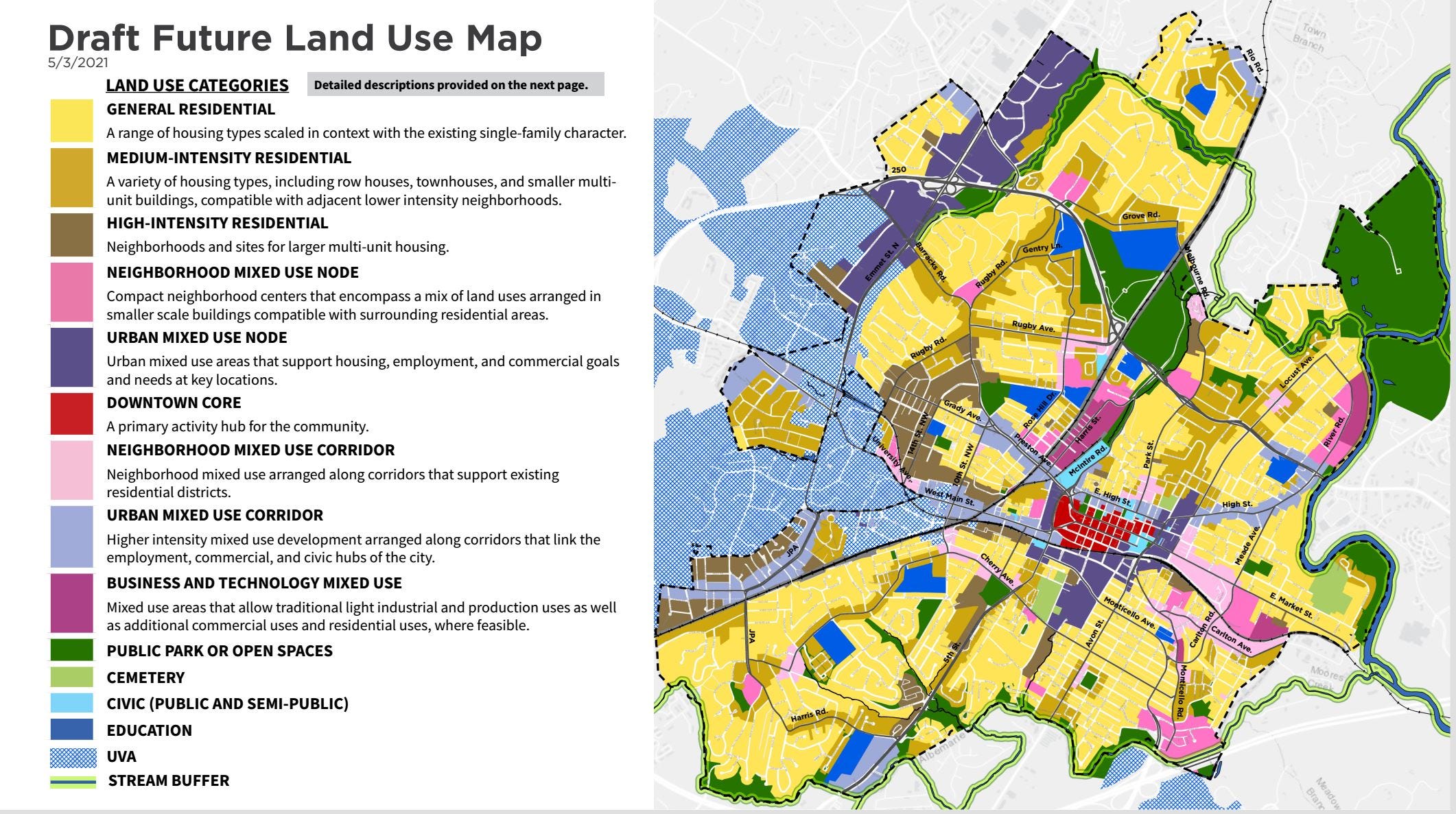
What had been called “Low Intensity Density” in the Future Land Use Map is now to be called “General Residential Density.”
The definition had read:
“A range of housing types scaled in context with the existing single-family character, such as 2-unit, 3-unit and accessory dwelling units (ADUs), where appropriate. Building heights range up to 2.5 stories. Allows limited ground floor active uses at select locations.”
The definition for General Residential Density is now more specific:
Uses: Up to 3-unit dwellings, and accessory dwelling units (ADUs). Limited neighborhood-serving ground floor active uses (shops, services, etc.) at intersections or locations deemed appropriate
Form: Respond to existing residential, environmental, and historic neighborhood context
Height: Up to 3.5 stories. Most in range of 2-2.5 stories.
Other changes:
Industrial Mixed Use is now known as Business and Technology Mixed-Use. Building heights would be up to six stories.
The Downtown Core is now depicted as red rather than dark purple.
The Neighborhood Mixed Use Node (dark pink) category would allow up to five story heights “internal to sites with appropriate depth to lower-intensity areas.”
The Neighborhood Mixed Use Corridor (light pink) category has also been extended to allow up to five stories.
Many early objections spotted on social media and neighborhood email lists appear to deal with areas painted light pink or dark pink. There is currently no written narrative for how these places were selected.
Areas suggested for nodes include an area north of the U.S. 250 bypass and Dairy Road interchange, the intersection of Jefferson Park Avenue Extended and Old Lynchburg Road, the intersection of Rugby Road and Barracks Road, a long stretch of River Road along the city’s eastern border.
A look at the draft Comprehensive Plan chapters
Previously, Rhodeside and Harwell have released guiding principles for the document.
Equity & Opportunity: All people will be able to thrive in Charlottesville
Community, Culture & Unity: Charlottesville’s rich and diverse culture and form will be celebrated, and the entire community will feel welcomed, valued and respected.
Local & Regional Collaboration: From the neighborhood to the region, open conversations and partnerships will make the city stronger.
Environmental Stewardship & Sustainability: The Charlottesville community will demonstrate environmental and climate leadership.
Connections & Access: The City will consider land use and transportation in complementary ways, creating more accessible and safer mobility options for all.
There guiding principles have now permeated into draft chapters that are to be reviewed. If you’ve not read a Comprehensive Plan before, each chapter establishes several goals for its given subject area and then recommends several strategies to achieve the goal.
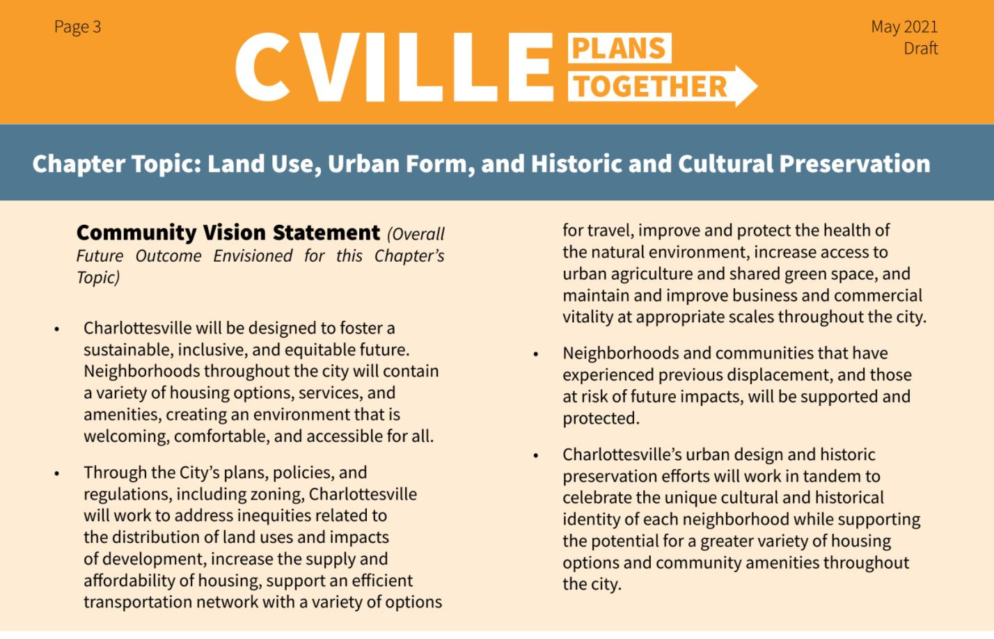
For instance, there are eleven goals in the Land Use, Urban Form, and Historic and Cultural Preservation chapter ranging from “Implementation of the Future Land Use Map” to “Historic Resource Protection.” Let’s take that first goal which in full reads “Implement the Future Land Use Map vision while supporting existing neighborhoods and preventing displacement.”
Detailed “sub-strategies” to get there appear to suggest that additional development should happen wherever it might fit. Language here includes “encourage infill development to address gaps in established or planned development patterns” and “where possible, encourage increasing intensity of uses through the reuse of reconfiguration of existing buildings.”
The fourth goal under this chapter calls for a zoning code and the first strategy is about finding ways to increase the number of multifamily housing across the city. This would include the establishment of mandatory inclusionary zoning to require below-market units in future multifamily developments. The intent is also to make these as easy as possible to build.
“Where multifamily development is allowed, incorporate transition zones and restructure restrictions on height, density, setbacks, and parking to ensure that multifamily mixed use development are feasible by-right without a special use permit,” reads the last paragraph in the section for Strategy 4.1.
Strategy 4.2 seeks to change zoning language to allow “soft density.” One plank looks back to the past.
“Increase the allowed intensity of housing in single-family neighborhoods that have had historically exclusionary zoning or policies (including racial covenants),” it reads.
There’s also a full draft chapter devoted to housing which has eight goals ranging from funding commitments to collaboration. The affordable housing plan calls for an annual $10 million in taxpayer funding for ten years, and that is called for Strategy 1.1 of the housing chapter. Half of this funding would go to subsidized housing costs for households with incomes less 30 percent of the annual median income. This chapter also repeats much of what was stated in the Land Use chapter.
The housing chapter also seeks to create a rent control system for Charlottesville, to require all developments to provide “enhanced tenants’ rights, and to increase subsidies for renters. There are also calls for a land bank, workforce housing built through the school system, and more.
Other items of note in the draft chapters:
The transportation section calls for a review of parking studies and suggestions to phase out minimum parking requirements in served by transit and high amounts of walkability. Strategy 4.4 calls for a park and ride lot somewhere, something Charlottesville Area Transit is already doing in the U.S. 29 north. There’s also a call for a regional Transportation Demand Management program.
The Environment, Climate, and Food Access chapter has a strategy to encourage urban agriculture through revamped open space standards. There is also language to promote a robust urban forest and to increase recycling and decrease items that find their way into a landfill.
The economic development chapter is now titled Economic Prosperity and Opportunity. One strategy calls out a proposal in the Starr Hill Vision Plan to connect the Jefferson School City Center to the Downtown Mall “physically and socially.”
There is now a new Community Engagement and Collaboration chapter.
Next steps:
The following opportunities exist for you to get involved and have your say:
May 10: Consultants will hold a virtual webinar from 6:00 to 7:30 p.m. (register)
May 14: There will be a pop-up in-person event outside of Reid Super-Save Market at 600 Preston Avenue from 1 to 3 p.m.
May 15: There will be a pop-up in-person event from 8 a.m. to noon at the Farmers Market at IX Park.
May 15: There will be a pop-up in-person event from 2 p.m. to 5 p.m. at the Jefferson School City Center.
May 19: The Cville Plans Together Steering Committee will meet from 5:30 p.m. to 7:30 p.m. (register)
May 25: Consultants will hold a second virtual webinar from 6:00 to 7:30 p.m. (register)
Take a look at the interactive Future Land Use Map and leave a comment.
Phone (833) 752-6428 and leave a message
I tweaked one line in the fourth paragraph after publication that did not adequately describe the nature of the disagreement among Planning Commissioners in 2018.