


The name of the initiative is Cville Plans Together, but an attempt to update the Charlottesville Comprehensive Plan to increase the number of affordable places to live at times seems like it could tear the community apart. Here’s one of over 50 community members who spoke this week during a five-hour work session on the topic.
“I wish this whole thing had been approached in a different way because it’s been so divisive and I’m sad to hear citizens of our community so upset with one another and I also wish we’d been able to talk in person,” said Mary Whittle.
On this installment of Charlottesville Community Engagement, a summary and recap of the review and preparation of an aspirational map intended to guide future development. I’m your host and guide, Sean Tubbs.
Most people in the community are unfamiliar with much of the jargon, but I’ve spent a good chunk of my career trying to explain the terms required to explain how the pieces fit together. Societies are complex organisms that have no instruction manual, but the goal of this newsletter and podcast, each and every time, is to help you better understand what’s happening. Thanks for listening.
In today’s first Substack-fueled shout-out, Code for Charlottesville is seeking volunteers with tech, data, design, and research skills to work on community service projects. Founded in September 2019, Code for Charlottesville has worked on projects with the Legal Aid Justice Center, the Charlottesville Fire Department, and the Charlottesville Office of Human Rights. Visit codeforcville.org to learn about those projects, and to sign up for a new volunteer orientation coming up this Saturday, September 4, at 4 p.m.
With four months to go until the end of 2021, the chair of the Charlottesville Planning Commission is hopeful Council will adopt a Comprehensive Plan before the clock strikes 2022. That will mark two years since the launch of the Cville Plans Together initiative. The firm Rhodeside & Harwell is leading the completion of the Comprehensive Plan, and subcontractor HR & Advisors has created an affordable housing plan that Council adopted in March. Preliminary work is underway on a rewrite of the zoning ordinance.
All of the work is done to fulfil a previous City Council’s request in the spring of 2019 to hire a firm to complete work on all three. Before we begin, let’s review the languages in the request for proposals. (read the RFP).
“Housing is at the root of historical structural inequity and oppression in the United States, and it came to be this way deliberately,” reads the request for proposals. “As we build a strategy to achieve a local housing landscape that is healthy, ample, high quality, and affordable, we must be equally deliberate in dismantling the dynamics and the structures that perpetuate continued inequity—structures that often go unnoticed by those of us who benefit from them or don’t directly experience their harm.”
In Late August, Rhodeside and Harwell released the third version of something called the Future Land Use Map which is intended to guide future development. In late March, the Planning Commission directed Rhodeside & Harwell to increase potential residential density allowed across the entire city but mostly in single-family neighborhoods. Some in those neighborhoods pushed back, and a third map balanced the two previous drafts.
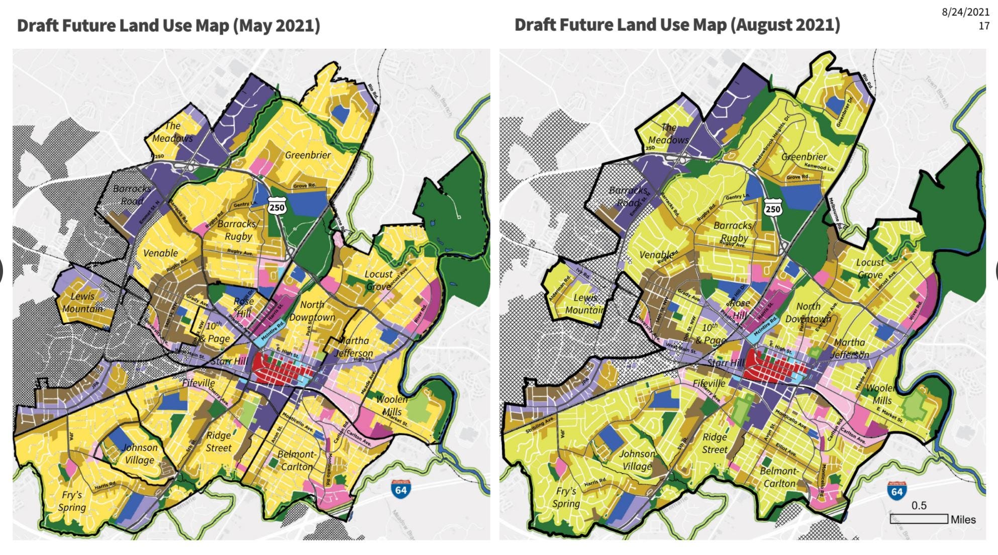
At a work session on August 31, the Planning Commission met for over five and a half hours to weigh in on the map. While not a public hearing, nearly sixty people spoke during the virtual meeting.
At the outset, RHI Project Manager Jennifer Koch stressed they were not reviewing a final product.
“This is a draft and we expect there may be adjustments that may be made to it,” Koch said. “If we do make revisions to the map after tonight, the Future Land Use Map, we will make it clear how and why those changes were made.”
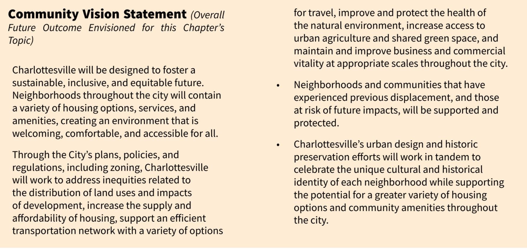
The Commission also reviewed the Land Use chapter of the Comprehensive Plan, which is connected to the Future Land Use Map.
“The land use map is connected to a variety of not only goals and strategies but also this overall chapter vision statement of what Charlottesville wants to be in the future related to land use, urban form, and historic and cultural preservation,” Koch said.
During her review of public engagement, Koch summarized two major camps that emerged during the input process earlier this spring.
“People who live in neighborhoods that are currently single family neighborhoods, there was a lot of expression of concern related to community character, development scale, and whatnot,” Koch said. “But I want to note there were a lot of comments and support for more housing, affordability and density in the city.”
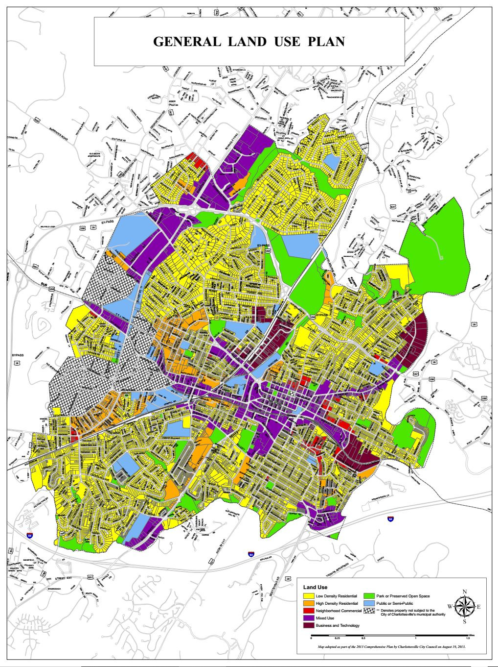
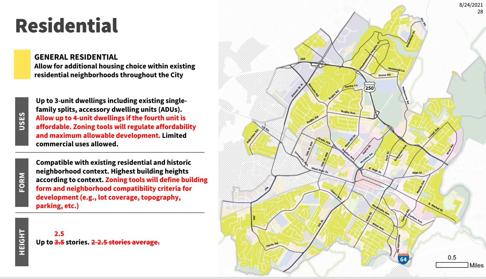
Koch said the Future Land Use Map is intended to implement the major tenets of the affordable housing plan. The current map dates back to 2013 and most of the city’s land is designated for low intensity residential. Beginning with the second draft map released in late April, that base level that has been renamed to General Residential.
“What we were talking about at this point was to allow up to three units on those sites and a lot of those right now are currently zoned for single family use only,” Koch said. “So that represented a potential tripling of what was allowed in those areas.”
Another change to General Residential is the ability for a property owner to build a fourth unit on a lot if that unit were kept below the fair market rent.
Corridors and nodes
Before we get too much further, a little bit of history. You might want to take a look at the implementation chapter from the city’s 2001 Comprehensive Plan. The word “corridor” is used over four dozen times. Here are a few examples from a plan adopted by City Council 20 years ago.
“We will support initiatives to increase commercial, retail and residential growth opportunities in our commercial corridors,” reads a progressive economic center vision principle.
“We will increase the amount of market rate, higher density residential housing downtown and along the economic development corridors,” reads a residential opportunities principle.
“Adopt zoning changes and urban design criteria to implement the recommendations of the Corridor Study,” reads a section on land use and zoning changes.
That study refers to a December 2000 Commercial Corridor Study that heavily influenced the last major zoning citywide zoning change in 2003. If you’ve ever wondered why there are taller buildings on West Main Street or dense apartment complexes on Jefferson Park Extended, that rezoning is why. (read about the study on cvillepedia)
Koch and her team of planners built all three drafts of the Future Land Use Map on the 2013 land use map, which builds off of the one from 2007 Comprehensive Plan. The review process never really ends.
But, a new plan has to be adopted, and on August 31, 2021, Koch wanted to explain a bit more about corridors and nodes.
“I want to be clear that when we’re talking about corridors and nodes in the city, we do have those land use categories that are called mixed-use nodes, mixed-use corridors,” Koch said. “But when we talk about a development pattern that is sort of node and corridor centric, we are also looking at things like residential corridors, you know, nodes of residential intensity.”
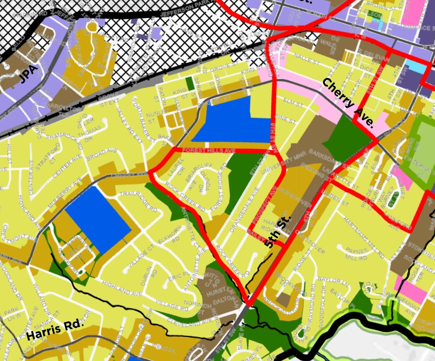
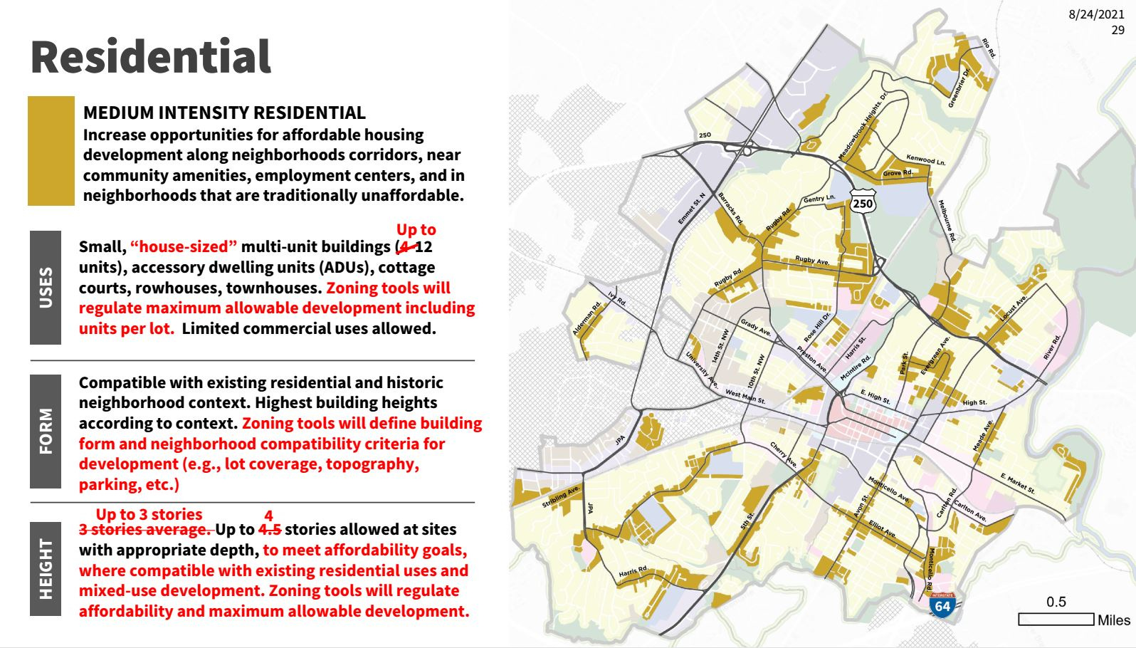
For instance, maps designate a section of Cherry Avenue west of Roosevelt Brown as increasing to Medium Density Residential. That’s within walking distance to Buford Middle School, a facility proposed to be upgraded in the near future to accommodate 6th graders. That area is also near Forest Hills Park and Fifeville Park.
“We’ve looked at how can we put potential intensity near schools and near parks, and that’s been important from the beginning of this process,” Koch said.
In the second version of the map, most of the Lewis Mountain neighborhood was designated as Medium Intensity Residential as were portions of the Greenbrier and Barracks / Rugby neighboorhoods. However, feedback led the consultants to scale back some of those to General Residential.
“We heard concerns about some locations of the medium intensity residential and the mixed-use nodes, and we heard concerns about the city’s ability to plan for infrastructure in advance of development, and that includes traffic, transportation, utility, stormwater, and other types of infrastructure,” Koch said.
Koch said others are concerned that simply allowing more housing units will not lead to reduced prices.
“We heard a lot of people who said density does not equal affordability and we 100 percent agree with that,” Koch said. “The land use map alone will not get to the housing goals that we have for Charlottesville.”
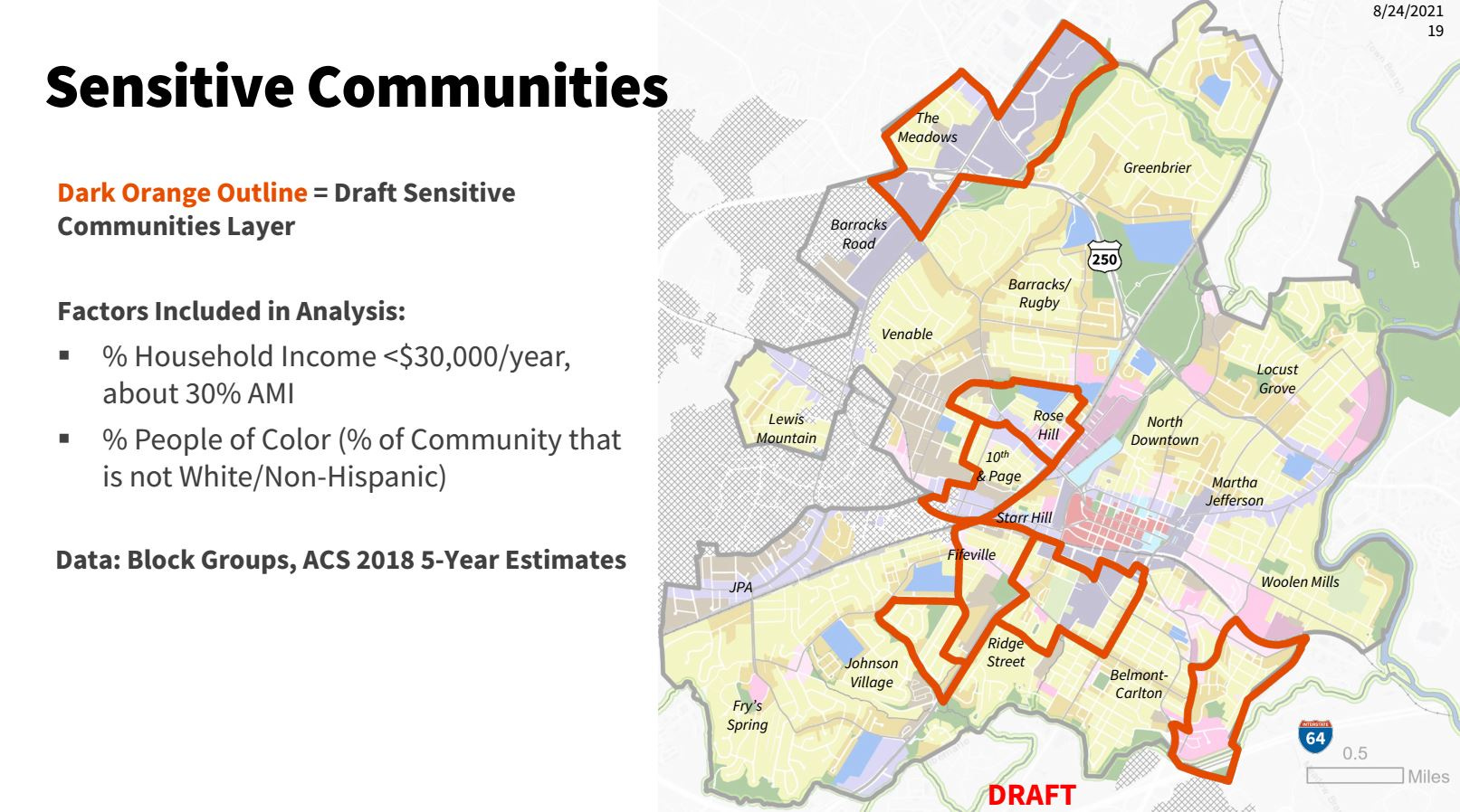
There has been concern about people being displaced from neighborhoods that have historically been home to Black residents and people with lower-incomes. For many years, real estate investors and wealthier households have purchased single family homes in 10th and Page, Fifeville, and Rose Hill and invested in them. A feature of the third draft of the Future Land Use Map would seek to restrict intense development in these areas.
“In the Future Land use map, to reduce the allowable intensity in those areas, we are proposing this Sensitive Community overlay that could then potentially include less development intensity in the zoning,” Koch said. “But we have heard mixed opinions on whether allowing less development in those areas would be preferable for those who may be in those at-risk communities. We want to make sure we’re not impacting potential wealth-building in those communities.”
We’ll hear more details about the changes in this third iteration of the map as Commissioners ask questions. For now, Koch said the changes made to the map, including the conditional allowance of a fourth unit in General Residential, could help the city attain its housing goals.
Over fifty people speak at public comment
Koch spoke for nearly an hour before members of the public were allowed to give their inputs. At that point in the call, there were 238 people watching the Zoom call. Over the course of the five hours meeting, nearly sixty people would speak. There’s not enough time to go through it all, but before we hear what Commissioners and the City Council think, let’s hear some voices skeptical opposed to the map.
“We had no idea that the ultimate goal of Charlottesville was to have this high density area,” said Michelle Rowan. “We specifically looked for something close to the hospital, R-1, coming off of acreage. That’s what we were looking for.”
“Is it really an issue of affordable housing or is it really an issue of poverty?” said Fred Borch. “Is the issue of poverty whether or not housing is affordable?”
“Census data has shown that construction of new homes in the city has outpaced the city’s population growth,” said Kaki Pearson.
“If the city of Charlottesville is serious about redressing housing and racial injustices, they could create a program to target individuals and families much like the voucher program created in Evanston, Illinois, where aggrieved African-Americans only need to show that they were descendants of residents during a certain time period,” said someone who was on the zoom call as Mary Simpson. “Instead, our government is proposing to dismantle single-family neighborhoods like mine. Yes, I will be punished twice. Let me be clear. I don’t want 12-unit buildings or commercial establishments in my neighborhood. I don’t want the traffic, the trash, the noise, the crime, and all of that which naturally accompanies denser neighborhoods.”
“I really would like to just make a huge plea to slow down the process and expand it,” said Martha Smythe. “We are still living in a pandemic which has changed everything and we’re talking about a rezoning which projects to alter everything in the city and I see no reason to rush it.”
“This plan being presented by the consulting team is what I believe to be an ideological blueprint for pro-density interests,” said Philip Harway.
“I want to confess that I do not share your goal of increasing density in the city and I don’t recall ever that ever being on any ballot presented to the citizens,” said Andrew Grimshaw.
There were also many comments in favor of the plan.
“I’m a little puzzled at all the outrage behind what’s being proposed given that the unit that I live in currently is pretty emblematic of a lot of the proposed changes, which is a converted house that looks just like all of the other houses on the block,” said Brendan Novak. “The only difference is that I can afford to live there whereas I could not live in an entire single family home for example.”
“Something that we noticed when were looking at the side-by-side slide of the August map and the May map is that there is in general a lot less gray in the historically exclusionary neighborhoods, the white neighborhoods,” said attorney Caroline Klosko with the Legal Aid Justice Center, speaking on behalf of the Charlottesville Low-Income Housing Coalition. “North Downtown, Lewis Mountain Road. Locust Grove. Barracks / Rugby. There’s less allowance for medium density than under the May version of the map and we think this is a step backwards and we’re disappointed by this.
“I hope we can move back in the direction that the first Future Land Use Map was going,” said Chris Schopper. “I feel like we’ve taken a step back.”
“I think that cutting down the General Residential stories from 3.5 to two is going to create issues in the long run,” said Tim Giles. “We’re going to have houses that can’t even be built in existing R-1 neighborhoods.”
“It’s important that this process considers to take the needs of renters and center them as we are fifty percent renters and probably will grow as that demand grows with the University of Virginia’s growth,” said Oliver Platts-Mills, a developer with several holdings in the Fifesville and Rose Hill neighborhood.
“I think you need to support a version of this plan that increases density across the city and allows all sorts of people who want to live here to be able to move here,” said David Singerman.
“I’d just like to express my support for the May revision that had more substantial changes to density across the city and I’d like to express my support for greater density in historically exclusionary neighborhoods as well as neighborhoods across the city,” said Jamelle Bouie.
You’re reading a special edition of Charlottesville Community Engagement on the Charlottesville Planning Commission’s August 31 work session on the Future Land Use Map and the Comprehensive Plan.
In today’s second Substack-supported public service announcement: The Charlottesville Jazz Society at cvillejazz.org is dedicated to the promotion, preservation, and preservation of jazz, and there’s no time like now to find a time to get out and watch people love to play. The Charlottesville Jazz Society keeps a running list of what’s coming up at cvillejazz.org. This week, find out that the Charles Owen Trio plays at Miller’s Downtown on Friday at 9:30 p.m., Zuzu’s Hot 5 will play the WTJU Free Fall Concert on Saturday, and the Beleza Trio plays at Potter’s Craft Cider also on Saturday. For details, visit cvillejazz.org.
But what did the Commissioners think?
When it was their turn, Commissioners had five minutes to ask questions and make comments. Commissioner Jody Lahendro has served on the advisory body since August 2014 and is one of the most critical voices on the Commission.
“I have been doing a lot of reading and most of the literature that I’ve come across has concluded that simply adding density does little to nothing to adding affordability to a city, or affordable units to a city,” Lahendro said.
The current draft allows a fourth unit in General Residential if it is subsidized or sold below its market value. Lahendro expressed skepticism.
“Why wouldn’t developers simply turn single family parcels into three residential units and take the money and run?” Lahendro asked. “Is the fourth unit based on some kind of data?”
Koch repeated that the Future Land Use Map and the zoning would not be enough, and that tools in the affordable housing plan would be required. But, size of units could play a role in bringing down housing costs.
“There is an opportunity to provide units that are more sort of naturally affordable if they are at a size that is not available in a neighborhood right now,” Koch said.
The zoning rewrite will be overseen by subcontractor Code Studio. Lee Einsweiler is the founding principal.
“You’re right, Jody,” Einsweiler said. “There’s no specific evidence that that fourth unit is somehow magically more affordable. It is just a trade-off we felt was reasonable for adding to our original three that if you were going to add more we needed some guarantee that some portion might be affordable.”
Lahendro said he could not support the additional density without precautions. He said developers will purchase existing homes, tear them down, and build three units where they can.
“The land has become more valuable now than the buildings that are on it,” Lahendro said. “Given the opportunity to provide more housing units on the same parcel of land through upzoning, developers will build more units but at market rates that will not meet the affordability definition.”
Lahendro said he could support the density of or three additional units in single-family zoning in if the units were guaranteed to be rented or sold at affordable levels. As a general rule, households who pay more than 30 percent of their income for the roof of their head are considered distressed.
Commissioner Lyle Solla-Yates said areas near the University of Virginia such as the Lewis Mountain neighborhood should be places where children in low-income families can live and have opportunity. He studied the changes to the Future Land Use Map over the weekend.
“And I only saw really large reductions in potential affordable housing there,” Solla-Yates said. “I didn’t understand it. I understand there has been public comment calling for less, especially among the highest-income homeowners. That’s really the big group that’s been pushing this story.”
Commissioner Taneia Dowell went next. She also supported Lahendro’s idea of an overlay district for additional units only if all are affordable.
“I too have some heartburn about the density in this plan,” Dowell said.
The newest Commissioner is Karim Habbab, who joined the advisory body earlier this summer.
“I think we need more assertive language regarding affordable housing and the affordability of the affordable housing throughout all different intensities and zoning requirements, not just the General Residential one,” Habbab said. “I think it could apply to most of them.”
Commissioner Rory Stolzenberg began his comments with a pointed question to the consultants.
“How do you decide whose opinions matter?” Stolzenberg said. “We’ve heard many hundreds of people’s feedback. Many people are arguing for one thing while many others are arguing for the direct opposite.”
Koch said the consultants have tried to strike a balance between multiple points of view.
“In terms of who we are listening to, we are trying to make that equity and affordability piece maintain strength and we think we have while also making compromise,” Koch said. “We are not swinging wildly one way or the other. I would say if we did that, if we really listened specifically to certain neighborhoods, a lot of these neighborhoods outside of those sensitive communities would not have any additional increase in potential density at all.”
Back to affordability. Stolzenberg said the city needs to provide incentives to developers if anyone is ever going to build the fourth unit. He said the nonprofit housing groups may not be interested unless they can build certain kinds of units in more places.
“My understanding in talking to our local housing nonprofits is that we have a couple of rental-oriented ones that don’t build buildings that size and you need at least 40 or 50 to get to a [Low-Income Housing Tax Credits] application,” Stolzenberg said. “And then we have homeownership ones like Habitat and the Community Land Trust. And for them, I think what they’re really seeking is for townhomes and in particular stacked townhomes. They keep saying stacked townhomes. That’s the fastest path to get affordability because land is so expensive and you can half the cost of land.”
Stolzenberg also said he did not favor a reduction in the number of stories allowed in General Residential from 3.5 in the second draft to 2.5 in the third. Commissioner Liz Russell picked up on this thread.
“It seems that the definition of missing middle housing is 2.5 to 3 stories, so if that’s what we say we want then that explains the reduction from 3.5 stories,” Russell said.
Russell said the process should result in a city that provides choices in housing.
“A range of housing opportunities in a way that is sensitive to the built form of our existing neigborhoods,” Russell said. “I think that’s what Cville Plans is working toward and I think it’s our role as Planning Commisioners to guide the density more specifically and not leave it to the market to decide what is built and what is affordable.”
This was Hosea Mitchell’s last meeting as chair. As such, he thought he would be candid in what said about the latest draft.
“The latest iteration disappoints,” Mitchell said. “The affordable housing plan that the consultants put together was designed to promote zoning and development that increased multifamily development in a way that buoyed equity and buoyed affordability in Charlottesville.”
Mitchell said the latest draft does not do enough to combat the long history of exclusionary zoning. Mitchell said he would support four stories in General Residential in places where it would make sense.
Three City Councilors weigh-in
The Commission’s role is advisory. Elected officials will make the final call. Let’s hear from three of them. First, Councilor Lloyd Snook.
“We have to remember that the Future Land Use Map is part of the Comprehensive Plan,” Snook said. “It is only about three pages of the Comprehensive Plan. The purpose of the Comprehensive Plan is to plan to deal with current and emerging problems. It is not particularly frankly to only preserve existing neighborhoods, though in some instances that could be a problem that we’re trying to address.”
Snook said the three values the Comprehensive Plan should address are racial equity, climate change, and affordable housing.
“Number three is dealing with all varieties of affordable housing,” Snook said. “We have to recognize that at the moment Charlottesville is becoming increasingly unaffordable for virtually everybody and that includes people who are making 100 percent of [area median income], not just 80 percent or 40 percent of 50 percent.”
Snook also said he wanted to see more information about the costs of building multiple units within one building.
Mayor Nikuyah Walker was on City Council in February 2019 when the decision was made to hire a firm to finish the Comprehensive Plan.
“I understand that a lot of people are challenged by Charlottesville, what has happened with past developments, the increase in pricing of housing and land, but there are certain members of our population who without us prioritizing them and especially the lower [area median income] they won’t be able to figure out in Charlottesville or existing areas,” Walker said.
Councilor Michael Payne said the Comprehensive Plan gives the change to change Charlottesville’s ecosystem for the better.
“Opening up the opportunity for more affordable homeownership and rental opportunity throughout the entire city and directly confronting the reasons that those opportunities aren’t available and allow more affordable duplexes, triplexes, townhomes to be built instead of having a system where you can only build a single family homes that’s selling for $600,000 or $700,000 in many cases,”
Payne said he was concerned that the latest version of the map was a step back in terms of meeting the city’s affordable housing goals. He said the longer the delay, the worse the housing ecosystem will get.
“Every day, week, month, and year the status quo continues and we know exactly what the status quo is, it’s gentrification, it’s displacement, it’s all the things that people continue to highlight as problems in our city,” Payne said.
Next steps?
Koch said she and her team will return to the Planning Commission at their regular meeting on September 14 for that review, and there is a work session slot reserved for September 21. The official public hearing will take place in October.
Between now and then, what are you going to do if you’re a Charlottesville resident? Have you taken a look at the map? Have you talked to your neighbors? As you’ve heard in this program, there are many opinions and thoughts. As you continue to read or listen to Charlottesville Community Engagement, I’ll continue to track this story, alongside the many other stories I write about land use, growth, economic development, and more of what makes this community function. Or not function. It’s a matter of perspective, but I’ll be here, documenting from as many views as I can.
Was this newsletter and podcast useful to you? Please consider support if you’ve not done so already. Here are some ways to do so:
Support general research by making a donation through Patreon
Sign for a subscription to Charlottesville Community Engagement, free or paid. Ting will match that amount!


Share this post