


If you are seeing this on the day it was published, yes, this is a Saturday. And this is a Saturday edition of Charlottesville Community Engagement. There are only a few of these in the two and a half year existence of this newsletter and podcast, and I apologize in advance there are no fun extras that come with publication on a weekend. No horoscopes, no comics, no puzzles. Only another in a long series of bulletins about informational happenings produced by myself, Sean Tubbs.
On today’s program:
A suspect has been arrested and charged with the second degree murder of a Charlottesville man last Saturday
Dominion Energy awards funding to several area projects
A look at the first draft module for Charlottesville’s zoning code which for the first time gives every property owner in the city a clearer idea of what can be built
Today’s first shout-out: The Great Migration: 20th Century African American Migration
UVA Lifetime Learning wants you to know about an upcoming event about a 20th century population trend. Between 1910 and 1970, an estimated six million African Americans moved from the South to cities in the North, Midwest, and West Coast; a demographic movement known as the Great Migration.
On February 16 at 3 p.m. Join Lifetime Learning and Kevin Gaines, the Julian Bond Professor of Civil Rights and Social Justice at the University of Virginia, as he discusses how this 20th Century wave of African American urban migration transformed American politics, culture, and society. This event is virtual and you can register in advance at the UVA Lifetime Learning website.

Suspect charged with second-degree murder
Charlottesville Police have arrested a 38-year-old Charlottesville man in the killing of another man late last month.
Tadashi Demetrius Keyes has been charged with second-degree murder of 36-year-old Eldridge Vandrew Smith on January 28, 2023 on Grove Street. Keys was taken into custody Friday afternoon.
“Charlottesville detectives, forensic technicians, and the Commonwealth Attorney’s Office have worked tirelessly since responding to the scene of this incident Saturday night to collect and process evidence, identify potential witnesses, and conduct a thorough investigation,” reads the press release.
For more on this story, take a look at the Charlottesville Daily Progress article published last night with more information about the suspect. (updated with correct spelling of suspect’s name)
Dominion awards funding to Ivy Creek Natural Area, Albemarle High School
A foundation associated with Dominion Energy has released a list of $1 million in funding awards for environmental projects across the country. Here’s some of the projects in Virginia’s Fifth District.
$5,000 for Albemarle High School for a program on water and air quality education
$5,000 for Appomattox County Public Schools for “Jump In To Watershed Education”
$5,000 for Buckingham County Elementary Schools for “Kids Care & Share Garden & Outdoor Classroom
$5,000 for the Goochland Educational Foundation for “STEM in Nature - Outdoor Education Experience “
$5,050 for the Ivy Creek Foundation for “Ecological Restoration at the Ivy Creek Natural Area”
$5,000 for the Rivanna Conservation Alliance for “Rivanna Watershed Experiential Education Project.”
Across the mountains in the 6th District, the Wildlife Center of Virginia received $12,000 for an environmental stewardship grant. Take a look at the full list for more projects.
For more information about the grant program, visit the Dominion Energy website.
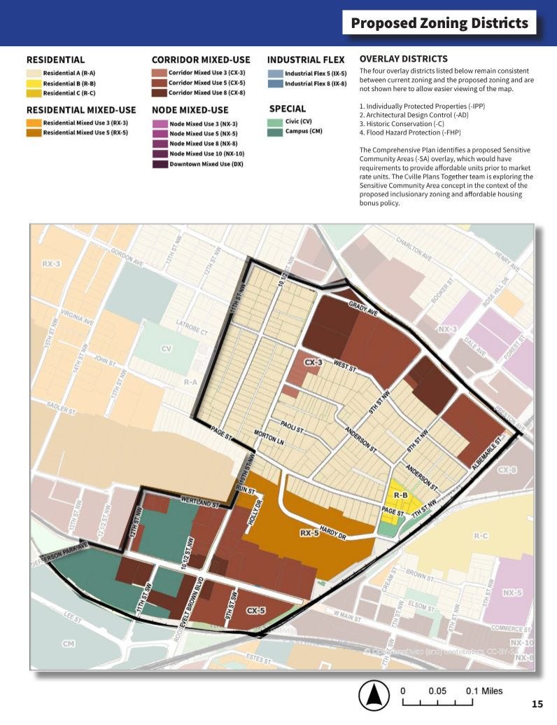
Charlottesville releases first set of new draft zoning rules including new map
After half of the summer, a long fall, and half of the winter, the city of Charlottesville has published the first draft materials for the new zoning ordinance. The city is referring to these as modules, and the initial installment includes the new proposed zoning districts and the new zoning map.
“The zoning rewrite is part of what we’re calling Cville Plans Together which is focused on updating the future for the city of Charlottesville with a particular focus on community equity and affordability for housing,” said Jennifer Koch of Rhodeside & Harwell in a YouTube video that seeks to explain the new map.
Resources from Cville Plans Together:
Draft Zoning Map (.pdf version)
Draft Zoning Map (interactive)
This work has now been underway for three years and saw the adoption of an Affordable Housing Plan in March 2021 and a new Comprehensive Plan in November 2021. The main idea is to allow more places to build housing all across the entire city.
“The new zoning districts correspond directly to the land use areas shown on the Future Land Use Map in the Comprehensive Plan,” reads the introduction to the material that was sent out late Friday night.
If you’re unfamiliar with the Future Land Use Map, it is a map in the Comprehensive Plan that gives a rough sketch of what the city would like to see built over time. The key feature of the Future Land Use Map is the provision of new development rights for almost all properties across Charlottesville. This zoning rewrite is intended to allow those rights to be turned into new places for people to live.
The previous Future Land Use Map adopted in 2013 designated about half the city as low-density residential, which corresponded with single-family residential zoning districts. Those will no longer exist in the new zoning as the General Residential category called for up to three units on most lots.
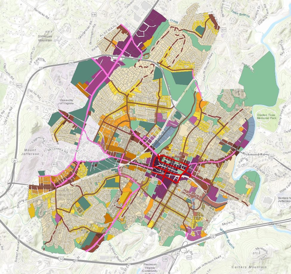
Other areas that had been low-density residential are now Medium Intensity Residential The draft zoning code splits this into two proposed zoning districts known as Residential-B and Residential-C.
“At a base level, the R-B allows up to 6 units, the R-C up to 8,” the introduction continues.
That’s before any of the city’s new affordability requirements would kick in. If a developer or landowner wanted to build more, they would have to comply with the city’s requirements to construct units that would be guaranteed to sell or rent at less than the market value. The units would specifically have to be reserved for households who make less than 60 percent of the area median income.
“There is an inclusionary zoning policy that requires the inclusion of 10% affordable units in developments of 10 or more homes, in any zoning district,” the introduction continues.
All lots in R-A would be eligible to have three dwellings but a total of four if an existing structure is preserved. A total of eight units could be built on R-A property if all of them are qualified as affordable. As much as 65 percent of the total lot area could be constructed upon if there are over four units. (edited for clarification)
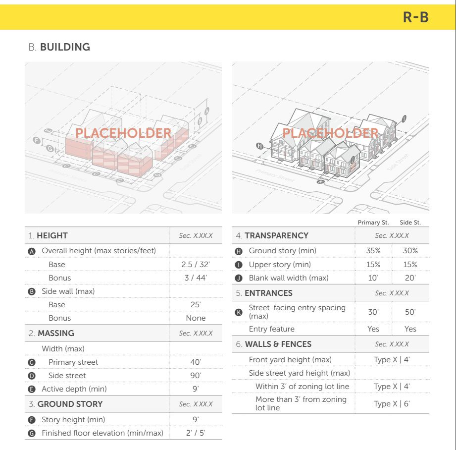
Height in R-A would be restricted to 32 feet, or two and a half stories. There would be no provision for bonus height.
The draft rules for R-B allow for up to 12 units if all of them are below market. Unlike R-A, there is no provision for existing setbacks to still need to be honored. New units could be built within ten feet of the primary street. Construction could be on seventy percent of the lot. (edited for clarification)
Construction in R-B zones could get a bonus height up to 44 feet for a total of three stories if all of the units are affordable. (edited for clarification)
R-C would allow a base height of 44 feet or three stories and up to 58 feet if all of the units are affordable. As many as eight units could be built at market-rate if no affordable units were provided, but there would be no provision for bonus height and density. If there are more than 12 units, construction could cover up to 75 percent of the property. (edited for clarification)
An example of R-B land is most of Cherry Avenue between Cleveland Avenue and Roosevelt Boulevard, with the exception of the intersection at Shamrock Road, a few houses close to Roosevelt Brown, and a 3.81 acre parcel owned by the United States government that’s currently used for an armory.
Second shout-out: WTJU seeks hosts for classical music
Have a passion for classical music? Want to listen to composers old and new... and then share those works with others? WTJU 91.1 FM Community Radio is seeking new volunteer hosts in its classical department! WTJU gives you all the tools and training you need to share your good taste with our loyal listeners. Learn more at wtju.net/getinvolved

A look at mixed-use districts
The existing zoning has many different mixed-use districts named for specific areas. The new zoning would make the names more descriptive beginning with Residential Mixed Use 3, or RX-3.
There would be no defined limit on the number of dwellings on the lot nor would there be any specific affordability requirements except for the standard requirement of 10 percent affordable for any development with more than ten units. There would be a maximum of 80 percent lot coverage allowed.
Buildings in RX-3 could be 44 feet tall, or three stories. There could be a maximum of 72 feet if bonus criteria are met. Ground floors must be ten foot floor to ceiling. The draft tables do not specify any minimum requirements for commercial use, or vice versa. These buildings could have a maximum width of 175 feet.
RX-5 is the next step up with a maximum height of 72 feet or five stories without any bonus. The structure could be up to 100 feet tall or seven stories if those criteria are met. These buildings would take up an entire lot as long as a ten percent outdoor amenity space is provided. Structures could have a maximum width of 275 feet.
One area designated RX-5 is the site where the Westhaven public housing community currently stands. Another is the western side of Fifth Street parallel to Ridge Street. Another is at Beacon on Fifth, a private development built as a Planned Unit Development under existing zoning.
The Future Land Use Map also designates other areas as either being nodes or corridors.
The two corridor mixed Use districts are similar to the residential mixed use district which begin to have more definitions for space depending on whether the use is residential or non-residential. Ground-floor residential would need to be a minimum of ten feet with nonresidential ground floors required to be as tall as 14 feet. CX-3 would have a range between a base of three stories and five stories if bonus criteria are met. CX-5 follows the same height rules as RX-5.
An example of CX-5 is the small stretch of East Rio Road within Charlottesville City Limits on land currently zoned for single-family residential. I wrote about that area for C-Ville Weekly last month. (edited - see comments)
CX-8 could take parts of Charlottesville to new heights. The base height allowed would be eight stories or 114 feet tall. With bonuses that could climb to ten stories or 142 feet.
The eastern side of West Main Street would be an example of CX-8, allowing for taller developments than what is currently allowed under the code. The western side is CX-5. (updated with a correction)
Another example of CX-8 is the parcel on Ivy Road that RMD Properties would like to build a nine-story building on. The Planning Commission is set to consider whether an exception can be made to allow that to happen under existing zoning. Read my story from January 10, 2023 for more info.
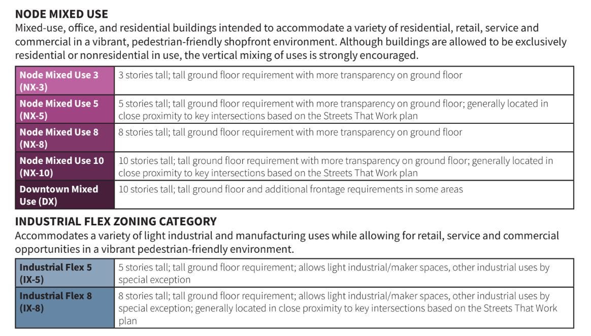
Then we get to the nodes which follow the same patterns as above, with NX-3 allowing the same 44’ to 72’ height range and NX-5 and NX-8 largely following the same as the corridor and residential districts listed above.
Each of these higher-intensity areas have varying rules for window requirements, massing, and other details. Some of these regulate different aspects of the building depending on whether a street is a “framework” street or a “local” street. These are defined in the Streets that Work plan.
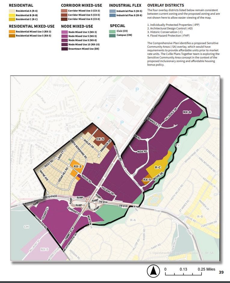
An example of NX-8 is the land between East High Street and 10th Street NE in the Little High neighborhood. Another is most of the commercial strip between U.S. 29 and Hillsdale Drive considered to be in the Meadows neighborhood.
The suffixes go up to 10 for nodes with NX-10. These would allow a maximum of ten stories in height or 12 stories if criteria for bonus provisions are met. This is very similar to DX for Downtown Mixed Use which adds different rules depending on relation to the pedestrian mall.
An example of NX-10 is Friendship Court, which is currently being redeveloped by the Piedmont Housing Alliance with investment of city infrastructure dollars. Another example of NX-10 is the land that used to be Vinegar Hill between what is now 4th Street NW and Ridge-McIntire Road.
There are similar zoning districts for industrial-flex areas with IX-5 and IX-8.
There are also “special” districts such as Campus (CM) and Civic (CV).
There are also provisions for “Alternative Forms” such as “Shopfront House,” “Civic Institution,” and “Park.”
Four existing overlay districts would remain in place. These are Individually Protected Properties, Architectural Design Control Districts, Historic Conservation, and Flood Hazard Protection zones.
A new overlay district is proposed for areas marked in the Future Land Use Map for areas prone to displacement of vulnerable populations. Those rules are not included in this module
Specific definitions begin on page 60 with items such as zoning lot and sublot. These are likely going to come into play later, so I conclude this summary with those definitions.
“A zoning lot is a parcel, tract, or area of land established by a plat or other means as permitted by law, which is to be used, developed, or built upon,” reads that definition.
“A sublot is a parcel of land, existing with other sublots on a single zoning lot, intended for the purpose of the transfer of ownership or possession or for development,” reads that one.
.
Next steps
The overall review will take place for the next few months.
“From now in February into the spring of 2023, we’re going to be sharing the draft ordinance in three parts to obtain your feedback,” Koch said.
One place to start your review is a summary of how these changes would alter each neighborhood. You can access that document here.
There are three upcoming open houses coming up later this month. These will be on February 22 at Charlottesville High School, February 23 at Buford Middle School, and February 25 at City Space. Keep an eye out for the Week Ahead that week for times and more details.
The next module will deal with the standards for each district. These include rules for parking, landscaping, signs, lighting, and other issues. That module is currently scheduled to be released the week of March 13.
After that will be the release of the final module which will take a look at the review processes.
Then the public hearings. Input received now could alter what ends up getting voted on.
To review the rules from the Cville Plans Together team, view the YouTube video. I had hoped to embed that here in this newsletter, but they’ve disallowed that function. So go here.
What do you think?
I am interested in your thoughts and would like to carry on a public conversation throughout this time. Want to be interviewed? Have a story you want to share? Let’s Talk!
Oh wait, that’s Albemarle’s catch-phrase.
Reading material
Construction on Belmont Bridge hits halfway point, Hawes Spencer, Charlottesville Daily Progress, February 1, 2023
Albemarle pondering ways to get developers to build more affordable housing, Anahita Jafary, NBC29, February 1, 2023
Despite public pushback, Board of Ed accepts draft history standards for first review, Nathaniel Cline, Virginia Mercury, February 2, 2023
Va. House won’t take up 20 constitutional amendments still pending in committee, Graham Moomaw, February 2, 2023
Filmmaker Lorenzo Dickerson uncovers hidden history in his family tree, Terry Menefee Gau, VPM, February 2, 2023
The zone for housekeeping for 494
I did not expect to write this today but when I began to read the material I canceled my plans for the day and got to work. Many of you come to rely on me to be there when it’s time write about a big land use issue. And here I am.
I first started writing about land issues in 2007 when I was hired by an entity that was created to focus on that topic. I left eleven years later with a deep knowledge of what had happened, and an almost insatiable curiosity for what’s going to come next.
And that’s what Charlottesville Community Engagement is for. Each and every installment begins with the basic questions of journalism and I’m blessed to pursue this work. It’s possible that there may be errors in this installment, and if so, I’ll correct them! I do not have any special magical knowledge of any of this stuff.
I’ve just put the work in.
Thank you to all of those who have supported the work to date, and thanks to all of those who will. No hard pitch today but I am obligated to mention Ting will match an initial Substack payment. That is incredibly value to my ability to keep asking the questions and to do what I can to inform as many people as possible.
Thank you to Liz Cerami and Valerie L’Herrou for their voice contributions in the podcast. Valerie wants you to know about the Virginia Poverty Law Center, protecting the rights of low-income Virginians.
Now, on to the Week Ahead, the Fifth District newsletter, and preparing for more installments of this newsletter. Thank you for your time, and please reach out if you have any questions. Leave comments. Let’s talk about it!


Share this post